

Most people looking at the Tugela Falls hike want to know three things before they commit: how hard the chain ladders are, how long the whole thing takes, and whether they are fit enough.
Those are the right questions. Reaching the top of Tugela Falls is a proper mountain hike, not a short walk to a viewpoint.
The Tugela Falls hike involves more than covering the distance. You need to prepare for steep climbs, exposed chain ladders and sudden changes in mountain weather.
The route you choose also affects the difficulty and time required.
This guide covers both routes, what the hike involves, and everything you need to decide and prepare before going.
Key Takeaways
Key Information | Quick Answer |
Main route | Sentinel route via chain ladders or the gully |
Return distance | Approx. 12 km via ladders; 8 km via gully |
Time required | 5 to 7 hours via the chain ladders |
Tugela Falls height | 948 metres across five cascades |
Difficulty | Challenging, with steep climbs and exposed sections |
Best time to hike | March to May; September to November is an alternative |
Hiking cost | Approx. R555 per adult with shuttle |
Essential preparation | Hiking boots, warm layers, water, food and offline maps |
How to Choose the Best Route to Tugela Falls?
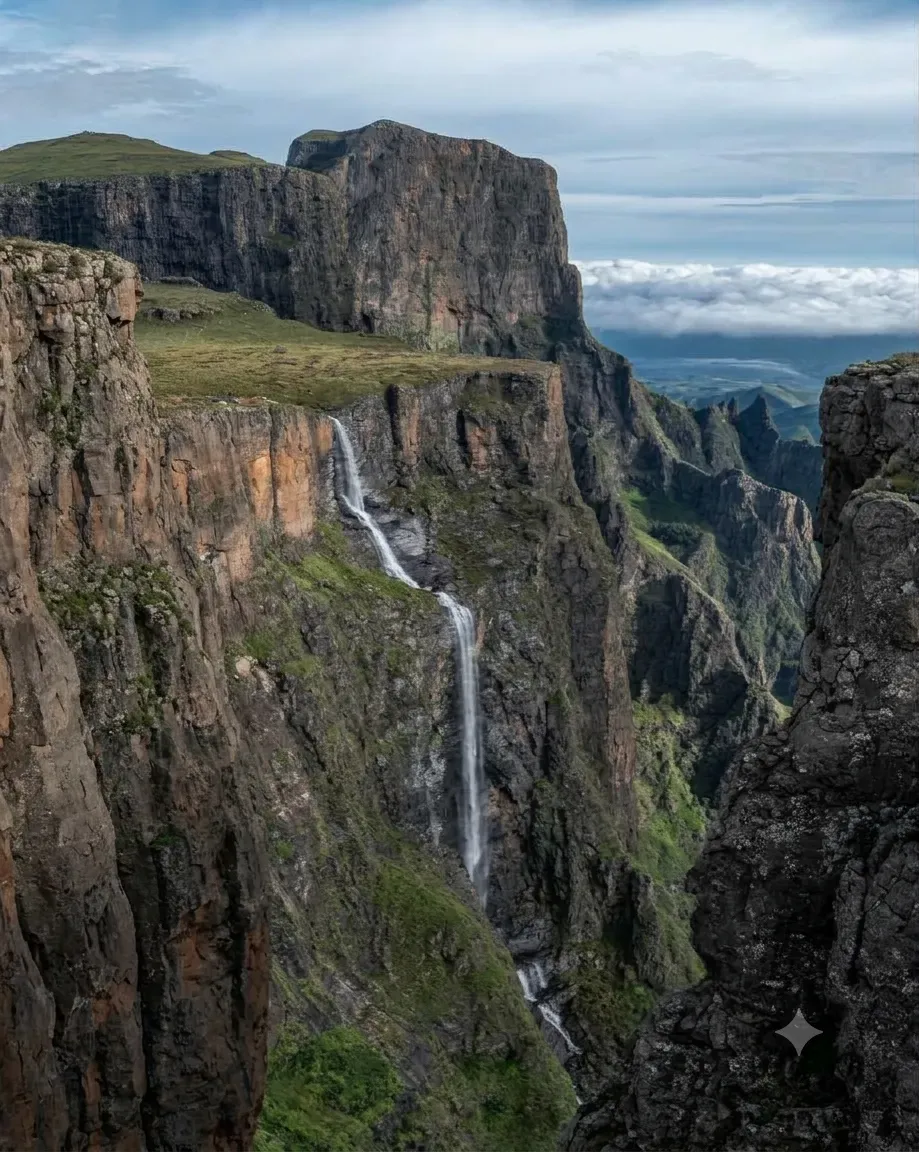 There are two ways to see Tugela Falls, and each offers a different view. The Sentinel route takes you to the top of the falls, while the Tugela Gorge Trail takes you through the valley below, where you can look up at the waterfall. Both offer different hiking experiences.
Route | What to Expect | Distance | Time | Difficulty |
Sentinel (chain ladders) | Climb to the Amphitheatre escarpment and walk across the plateau to the lip of Tugela Falls | ~12 km return | 5 to 7 hours | Challenging. Steep climbs and exposed chain ladders. |
Sentinel (Beacon Buttress Gully) | Climb a steep, rocky gully to bypass the chain ladders, then continue to the top of the falls. | ~8 km return | 5 to 6 hours | Very challenging. Loose rocks and steep scrambling. Avoid in wet conditions. |
Tugela Gorge Trail | Walk through the valley below the Amphitheatre and see the falls from below. | ~15 km return | 5 to 6 hours | Moderate. Rocky paths and river crossings. |
The Sentinel route is the one most people mean when they say the Tugela Falls hike.
What Is the Tugela Falls Hike Like?
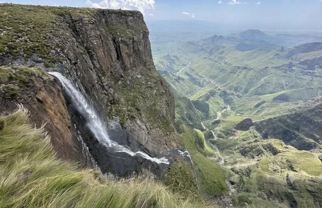 The hike follows a logical sequence from the car park to the top and back. Here is what each stage involves.
Stage 1: Sentinel Car Park to the Viewpoint
The trail starts at the Sentinel car park. You are at about 2,500 metres here. The first stretch is uphill, but steady. The path is clear and runs through open grassland.
Walk for 30 to 40 minutes. You reach a viewpoint over the valley. The trail is well marked, and the climb is easy enough. It is a good spot to pause before going on.
Stage 2: Viewpoint to the Decision Point
The path keeps climbing, and it gets steeper now. The Sentinel Peak shows up ahead.
After about 90 minutes, you reach a split. One way leads to the chain ladder route. The other leads to the gully route. A sign here may say whether the ladders are open. It is not always up to date, so check before you visit.
Stage 3: The Chain Ladders
Two chain-ladder options reach the plateau, one on the left and one on the right. They sit below the Beacon Buttress. The ladders are metal and fixed in place. They date back to the 1930s and have been kept up since.
Each flight takes a few minutes to climb. The exposure is real. You are on a vertical face, with the valley far below. If heights make you uneasy, this part will test you. Most hikers manage it, but it is not an easy section.
Stage 4: The Beacon Buttress Gully Alternative
If the ladders feel too exposed, there is another way. The gully bypasses them. It is a steep scramble up loose rock, off to the right.
The gully is not marked or maintained. In places, it is steeper than the ladders. Avoid it when the rock is wet. Do not think of it as the easier option. You swap exposure for loose footing. The effort is harder too.
Stage 5: The Plateau to the Falls
Climb past the ladders or the gully. The ground flattens out. You are now on the Mont-aux-Sources plateau, at about 3,100 metres. Walk on for about 20 minutes. The ground is open and flat. Take your time here. You are heading for the lip of the Tugela waterfalls.
The edge is exposed. There is no fence. Stay well back if the wind picks up or the mist rolls in.
How Difficult Is the Tugela Falls Hike?
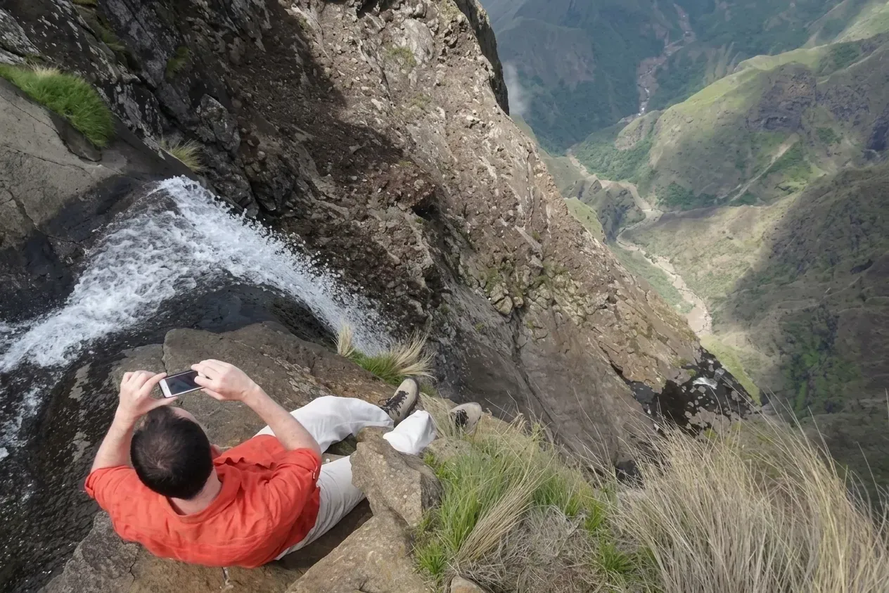 The hike is classified as moderate to challenging. The first two hours are a steady climb on a clear path. The chain ladders or gully add a short but genuinely difficult section. The altitude (above 3,000 metres at the top) can affect people who are not accustomed to it. The return descent is hard on the knees, and afternoon thunderstorms can move in quickly.
- Fitness: You need to be comfortable walking uphill for 2 to 3 hours without extended breaks
- Heights: The chain ladders require climbing a vertical rock face. The gully requires scrambling on loose, steep ground.
- Weather exposure: The plateau is fully exposed. Conditions can change from clear to fog, rain or cold within minutes.
- Navigation: The trail is reasonably clear on the lower sections but less defined on the plateau. Offline maps or a GPS device are worth carrying.
What Can You See at the Top of Tugela Falls?
The lip of the falls sits on the edge of the Amphitheatre. Here, the Tugela River drops 948 metres in five cascading stages to the valley floor. This is what you will see:
- The falls are dropping away. The river tips over the edge and falls in five stages. You look straight down the cascade.
- The escarpment. On a clear day, the view runs far across the escarpment.
- Royal Natal National Park. The park lies spread out far below you.
- The Drakensberg peaks. Ridge after ridge rises around the Amphitheatre.
- Height and space. The sense of scale is the real reward of the climb.
- A flow that changes. The falls look strongest after rain. In dry spells, they shrink to a thin stream.
When Is the Best Time to Hike to Tugela Falls?
March to May is generally a good period to plan the Tugela Falls hike, with September to November as another option. However, mountain weather can change quickly, so check the forecast before setting out.
Season | Months | What to Expect | Hiking Advice |
Autumn | March to May | Comfortable temperatures and generally lower thunderstorm risk than in summer. | Preferred period for planning the hike, subject to the forecast. |
Spring | September to November | Warming weather and seasonal wildflowers. Thunderstorm risk increases as summer approaches. | Good alternative. Check the forecast before starting. |
Summer | December to February | Afternoon thunderstorms can make the exposed plateau dangerous. | Start early, but postpone the hike if thunderstorms are forecast. |
Winter | June to August | Cold conditions, with possible ice on the chain ladders and in the gully. | Best suited to experienced, well-equipped hikers. |
How to Reach the Tugela Falls Trailhead?
There are two main ways to see Tugela Falls. Each gives you a different view. The Sentinel route takes you to the top. You stand at the edge of the falls. The Tugela Gorge Trail does the opposite. It follows the valley below, so you look up from underneath the Amphitheatre.
1. Sentinel Route Trailhead Access
You will find the Sentinel car park at the end of a rough dirt road. It runs 7 km above Witsieshoek Mountain Lodge. The last stretch is tough. Take a 4x4, or hop on the lodge shuttle.
Travel Option | Price | Time | Details |
Witsieshoek Mountain Lodge shuttle | Approximately R320 return per person | 30 to 45 minutes | Runs at scheduled times, typically four departures each way. Book in advance. |
Own 4x4 | Fuel and vehicle costs | Allow 30 to 60 minutes for the final 7 km | You can drive to the Sentinel car park if your vehicle can handle rough tracks. Standard cars cannot manage the final 7km. |
From Johannesburg | Depends on transport | 4 to 5 hours | Drive to Witsieshoek via the N3. |
From Durban | Depends on transport | 4 hours | Drive to the Royal Natal area. |
Tugela Gorge Trail Access
The Tugela Gorge Trail shows the falls from below. You do not climb to the top this time. The trail starts at the Royal Natal National Park visitor centre. From there, it follows the Tugela River into the gorge.
Detail | Information |
Starting point | Royal Natal National Park visitor centre |
Transport required | No 4x4 or lodge shuttle needed |
Trail route | Follows the Tugela River into the gorge below the Amphitheatre |
View of Tugela Falls | Views of the falls from below |
What to Pack for the Tugela Falls Hike
The hike becomes more enjoyable when you carry the right items. The route to the peak has uneven trails, rocky paths and changing weather. So, the items that will be helpful on your hike are listed below.
Item | What to Pack |
Water | At least 2 litres per person. |
Food | Enough lunch and snacks for the day. |
Navigation | Download offline maps. Phone signal can be patchy. |
Sun protection | Try to carry sunscreen and a hat. |
Gloves | Carry them in winter. The metal ladder gets cold. |
Hiking boots | Sturdy boots with good grip and ankle support. |
Warm layers | A warm jacket, even in summer. |
Rain jacket | It's better to carry a waterproof jacket year-round. |
How Much Does the Tugela Falls Hike Cost?
You need to pay the park entry and hiking fees. If you take the Witsieshoek shuttle, you’ll need to pay extra for the ride.
Item | Cost (2026/2027) |
Conservation fee (toll gate) | R90 per adult |
Day-hike fee (Sentinel car park) | R145 per adult |
Witsieshoek shuttle (return) | R320 per person (book in advance) |
Total (with shuttle) | Approximately R555 per person |
Total (own 4x4, no shuttle) | Approximately R235 per person |
Where to Stay for the Tugela Falls Hike
If you're taking the Sentinel route, stay at Witsieshoek the night before. You can catch an early shuttle and finish the hike before the weather gets worse in the afternoon.
- Witsieshoek Mountain Lodge: The closest stay to the Sentinel trailhead. You can choose lodge rooms, hiker cabins or chalets. The shuttle leaves from here, so book early during busy months.
- Mahai Campsite (Royal Natal): A basic campsite inside the national park, close to the Tugela Gorge Trail.
- Amphitheatre Backpackers: Another option near Royal Natal, convenient for those taking the gorge trail.
Conclusion
The Tugela Falls hike is one of the best day hikes in South Africa. The views from the top of the Amphitheatre make the effort worth it. You will find the chain ladders challenging, and the gully tests you in a different way. Once you reach the plateau, the landscape opens up to views you cannot see from the lower trail.
A few things matter. Check current access before you go. Start early. Watch the weather. Be honest about what the exposed sections ask of you. Holiday Tribe builds the Drakensberg and Tugela Falls into South Africa holiday packages. These combine the mountains with Kruger, Cape Town and the wider country.